Safest Way: How Location Data is Helping Create Safer Journeys
How location data can help create safer public spaces
The recent announcement of London’s new £15.6 million Safer Public Spaces Fund signals a growing recognition that creating safer, more inclusive places requires more than physical infrastructure alone. The initiative will put women and girls at the heart of designing and improving public spaces across the capital, supporting practical interventions aimed at helping people feel safer in their everyday lives. While improvements such as better lighting, increased visibility and more thoughtful urban design have an important role to play, data and technology are also becoming part of the solution.
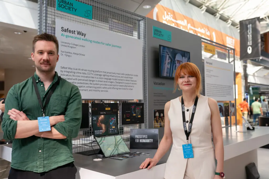
One startup exploring this challenge is Safest Way, a Geovation Accelerator-supported venture using location intelligence to help people make more informed decisions about their journeys. As the team explains:
Why public safety is also a data challenge
How safe a place feels is often influenced by a combination of factors. Lighting, visibility, activity levels and familiarity with an area can all shape how people experience public spaces, particularly when travelling alone or after dark. As cities continue looking for ways to create safer environments, there is growing interest in how data can help people better understand their surroundings and make informed decisions about where and how they travel.
Location data plays a particularly important role because it provides context. It helps us understand not only where something is, but how different pieces of information relate to a place and to each other. When data is brought together effectively, it can reveal insights that would otherwise remain hidden.
For startups and innovators, this presents an opportunity to transform complex datasets into practical tools that support everyday decision-making.
How Safest Way is using location intelligence
Safest Way was founded to address a challenge familiar to many people: deciding which route to take when travelling through an unfamiliar area or walking after dark. To do this, Safest Way combines location-based information to provide a more informed picture of the environment.
One of the first datasets used by the platform is Ordnance Survey’s Open Greenspace data, which provides information on parks and other open areas. Research, alongside work undertaken with women and the Metropolitan Police, highlighted that these environments can feel less safe after dark. As a result, routes through many open green spaces are penalised or excluded when generating night-time walking directions.
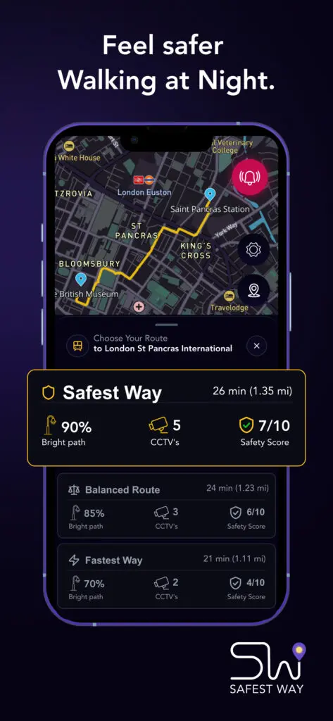
This data is supplemented with woodland data from OpenStreetMap, alongside police crime data and local authority datasets covering features such as street lighting and CCTV. Together, these sources help build a more detailed understanding of the walking environment surrounding a route.
As the platform has grown, user feedback has also become an important source of insight. Information about routes that people prefer or choose to avoid helps provide valuable local context and supports the ongoing refinement of Safest Way’s routing algorithms.
By bringing these datasets together, the platform helps users make more informed decisions about the routes they choose and the environments they move through.
Turning location data into everyday impact
One of the greatest strengths of location data is its ability to make information relevant and actionable.
Datasets on their own can be difficult for people to navigate or interpret. However, when that information is connected to places, routes and real-world decisions, it becomes significantly more valuable. This is where innovation plays a critical role. Startups are often able to identify practical applications for data that may not have been considered before, creating solutions that address real-world challenges facing individuals, businesses and communities.
Safest Way provides an example of how location intelligence can move beyond traditional navigation use cases and support broader objectives around public safety, accessibility and confidence in public spaces.
How Geovation supported the journey
When Safest Way joined Geovation’s Cohort 19 of the Accelerator Programme in 2024, the team already had a clear vision: helping people make safer decisions about the routes they take.
Turning that vision into a scalable product required access to the right combination of expertise, data and support. Through the accelerator, Safest Way was able to draw on Geovation’s network of mentors, partners and geospatial specialists while exploring how trusted location datasets could strengthen and refine its approach.
The programme also provided opportunities to test ideas, build connections and learn from a wider community of founders tackling challenges through location intelligence. These insights helped shape the platform as it continued to grow and expand into new locations across the UK.
Today, Safest Way remains part of the Geovation alumni network, demonstrating how location data can be applied to create solutions with meaningful social impact.
Scaling impact
As conversations around public safety continue to evolve, so too does the opportunity for technology and location intelligence to support positive change. Safest Way has continued to expand its reach, bringing its solution to new locations and making its service available to more users.
This growth reflects increasing interest in technologies that help people better understand and navigate the environments around them. At the same time, initiatives such as London’s Safer Public Spaces Fund highlight a broader commitment to making places safer and more inclusive through collaboration between public sector organisations, communities and innovators.
Together, these efforts demonstrate how data, technology and local insight can complement investments in the built environment to create more confident and inclusive journeys for everyone.
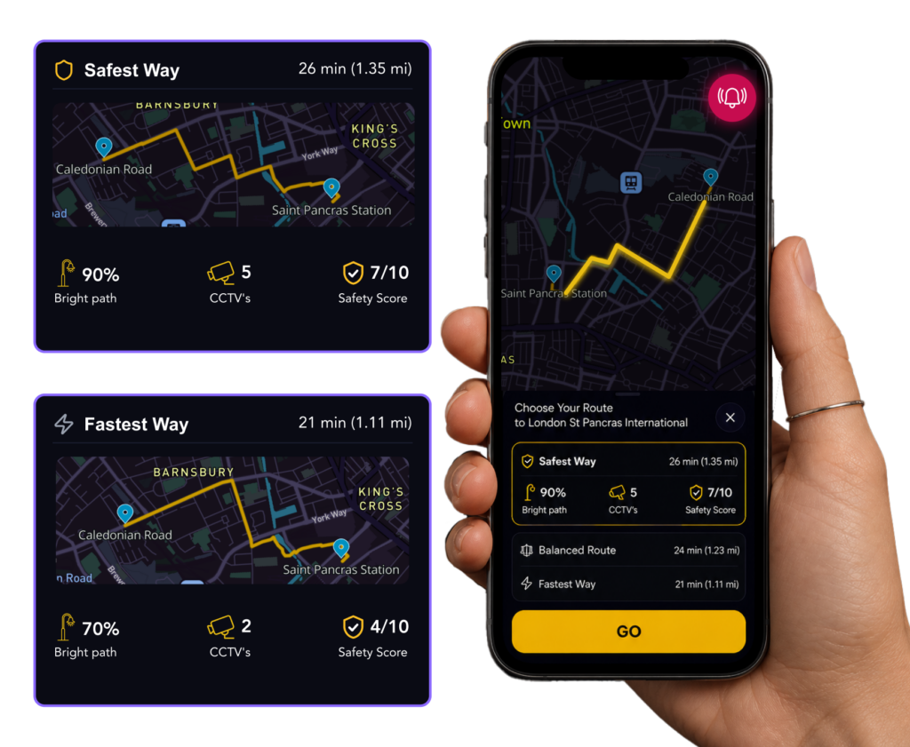
Learn more: Discover more about Safest Way and how the team is using location intelligence to support safer journeys.
You can also find out more about the Geovation community and accelerator:
- Meet the start-ups
- Learn more about the two-track Accelerator Programme
- Join the community and become an Ecosystem member
Marketing That Actually Works


AI for Marketing
Founder Wellness: Pottery Mug Making