Optimal Cities: a GeoTech startup story
Making Cities That Heal – The Next Chapter in Urban Planning
The Trilemma: Making thriving places for People, Nature, Portfolios
Planning a healthy city is a complex task, involving many factors like public health, housing, green space, viability, policy, infrastructure, soil, air and water quality. It’s hard to get all of these things right, and even harder to keep them in balance as a city grows and changes.
Plan making is complex and often done blindly – and for good reason. It is either because there’s too much data to analyse or not enough actionable intelligence. But good planning is important, especially since around 60% of our health is influenced by our environment. And poor planning can have multi-trillion consequences, costing the UK an estimated £50 billion and the USA over $1 trillion per year.
Today, a planner spends around 80% of time doing research, navigating through conflicting evidence and outdated documents and data. That takes away valuable time that could be spent on engagement and creative solutions. With new requirements coming in like Environment Outcome Reporting, Biodiversity Net Gain and the Levelling Up Bill, there is a desperate need for planning evidence to become more up-to-date.
Let’s just talk about emissions for a moment. Planning teams are already under pressure to reduce them alongside other priorities like affordable housing. With upcoming regulations and targets expanding globally, there’s no way to deliver plans that can respond to complex challenges while skills and human resources are not aligned with the magnitude and urgency of those challenges
But how do we even start?
It’s essential to ensure that planners and developers reduce their cognitive overload so they can focus on making places where people enjoy living and working in cities.
What we need is a radical change: simple tools that can augment plan makers with actionable intelligence that responds to meaningful questions.
Optimal Cities is an all-in-one decision support system to give planners superpowers enabled by intuitive geointelligence.
make people, cities and nature coexist symbiotically.
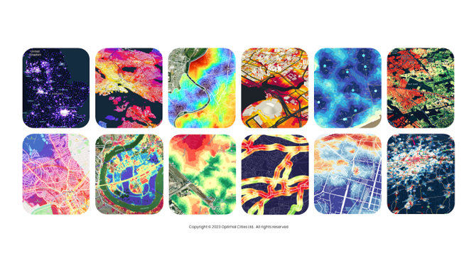
Optimal Cities is harnessing the power of satellites and AI to provide bespoke mapping tools with fresh location intelligence to boost planning and development in a healthy way, at global scale.
By unifying human wisdom, satellites, GeoAI, and intuitive interfacing, planners have a better chance of delivering on complex aspirations.
GeoAI is used to analyse complex spatial data and identify patterns and correlations that would be difficult for humans to see. This information can then be used to validate assumptions and develop plans that are more likely to be successful.
Show me your data and I will show you your future. Reliable data and intuitive interfacing can help planners to communicate with the public and get feedback on their plans. This can be used to improve the plans and make them more likely to be aligned with what people need
Silviu Pirvu FRSA, CTO Optimal Cities
Aiming beyond Healthy Cities
There are examples around the world where cities are not only places of economic prosperity and innovation, but also places where people can improve their life expectancy, such as Singapore.
The mission of Optimal Cities is to enable a world where cities are planned and built in real time using fresh intelligence so that people and nature can coexist and adapt to ever-changing aspirations.
By harmonising the interplay between people, environments, and technology to deliver healthy outcomes, we can make more than healthy cities.
With the right tools, we can finally make cities that heal. Even more, we can track and discover what works and replicate best practices globally.
Learn more about Optimal Cities and get in touch:
- Our website: https://optimalcities.com
- Linkedin: https://uk.linkedin.com/company/optimalcities
- Optimal Cities in the RICS Tech Partner programme: The convergence of technology, sustainability, and urban planning: https://www.rics.org/news-insights/the-convergence-of-technology-sustainability-and-urban-planning
- Optimal Cities talking about the power of satellites and AI for healthy city development at the UN General Assembly Science Summit 2023: https://sciencesummitunga78.sched.com/event/1Nr86/virtual-medical-advances-towards-the-sdgs-achievements-from-human-space-exploration-220902